
User's Guide
1.Search
You can search for facilities from the top page. There are four search methods available.

① Search by Facility Name
If you know the name of the facility you're looking for, search here.
Enter the facility name in the "Search by Facility Name" keyword field and press the "Search" button.
If you know the name of the facility you're looking for, search here.
Enter the facility name in the "Search by Facility Name" keyword field and press the "Search" button.

② Search by Area
If you have decided on the area you want to use, search here.
Select the corresponding area from the area list displayed in "Search by Area" and press the "Search" button. To search from multiple areas, select all relevant areas and press the "Search" button.
If you have decided on the area you want to use, search here.
Select the corresponding area from the area list displayed in "Search by Area" and press the Search button. To search from multiple areas, select all relevant areas and press the Search button.

③ Search by Purpose/Conditions
If you want to find facilities according to your purpose or conditions, search here.
Select the relevant items from the "Search by Purpose/Conditions" icons and press the Search button.
If you want to find facilities according to your purpose or conditions, search here.
Select the relevant items from the "Search by Purpose/Conditions" icons and press the Search button.

④ Search by Barrier-Free Facilities
If you have decided on the barrier-free facilities you need, search here.
Select the relevant items from the "Search by Barrier-Free Facilities" icons and press the Search button.
If you have decided on the barrier-free facilities you need, search here.
Select the relevant items from the "Search by Barrier-Free Facilities" icons and press the Search button.
2.Open Barrier-Free Map

Click "Open Barrier-Free Map" on the top page to open the Fukushima City Barrier-Free Map.
Facilities will be displayed filtered by the search method you specified on the previous screen.
Click "Open Barrier-Free Map" on the top page to open the Fukushima City Barrier-Free Map.
Facilities will be displayed filtered by the search method you specified on the previous screen.

Screen Layout
The Fukushima City Barrier-Free Map consists of three blocks "Facility List," "Map Display," and "Filter Conditions" from left to right.
The map displays the area specified in the previous search method. If no area filtering was performed, barrier-free facilities around Fukushima Station will be displayed on the map.
The location of each facility is indicated by a Momorin icon.
The Fukushima City Barrier-Free Map consists of two blocks, top to bottom.
From top to bottom "Map Display" and "Filter Conditions." The map displays the area specified in the previous search method. If no area filtering was performed, barrier-free facilities around Fukushima Station will be displayed on the map.
The location of each facility is indicated by a Momorin icon.
Press the "View Facility List" button surrounded by a dotted line to display the facility list. Press the hamburger menu button to open and close the menu.

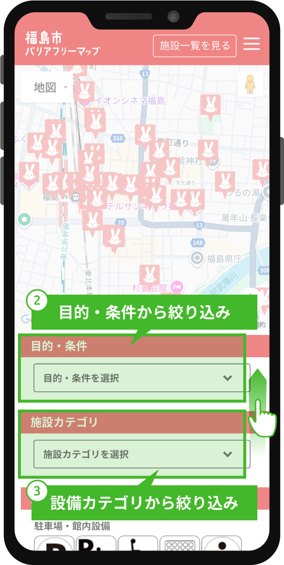
Refine Conditions
Refine Conditions (1)
You can further refine from the search conditions specified on the previous screen.
① Press the buttons in "Area" to switch the center map to the target area. (Iizaka Onsen / Tsuchiyu Onsen / Takayu Onsen / Central City Area)
② Select your desired purpose/conditions from the "Purpose/Conditions" dropdown to filter facilities that match the conditions.
③ Select your desired facility category from the "Facility Category" dropdown to filter facilities that match the conditions.
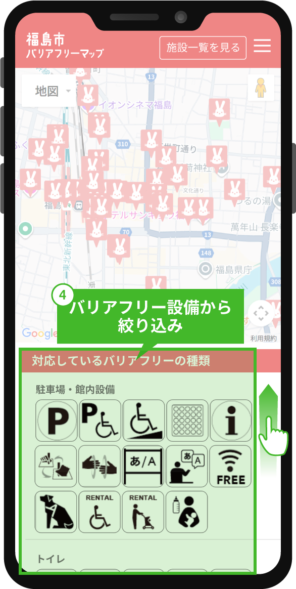
④ Press the pictograms in "Available Barrier-Free Types" to filter facilities that match the conditions.
You can further refine from the search conditions specified on the previous screen.
① Press the buttons in "Area" to switch the center map to the target area.
Refine Conditions (2)
Scroll the lower area to display the next items.
② Select your desired purpose/conditions from the "Purpose/Conditions" dropdown to filter facilities that match the conditions.
③ Select your desired facility category from the "Facility Category" dropdown to filter facilities that match the conditions.
Refine Conditions (3)
Scroll the lower area further to display the next items.
④ Press the pictograms in "Available Barrier-Free Types" to filter facilities that match the conditions.

Check Facilities
Click on a Momorin icon displayed on the map to check the barrier-free features of the target facility.
Click "Details" in the window to switch to the detailed screen of the target facility.
Click "Route" in the window to launch Google Maps.
Click on a Momorin icon displayed on the map to check the barrier-free features of the target facility.
Click "Details" in the window to switch to the detailed screen of the target facility.
Click "Route" in the window to launch Google Maps.

Check Facility Details
On the facility detail screen, mainly use the navigation buttons located at the top center.
Press each button to scroll to the position where you can view the target image. Barrier-free features are displayed in blue on the right side of the screen.
On the facility detail screen, mainly use the navigation buttons located at the top center.
Press each button to scroll to the position where you can view the target image.
Icons for barrier-free features are displayed in blue.

Support Information Display
Some facilities have information about available support services.
Some facilities have information about available support services.
3.View Street View

① Select Pegman
Select the Pegman (yellow human-shaped icon) at the bottom right of the center map screen.
Select the Pegman (yellow human-shaped icon) at the bottom right of the center map screen.

② Drag to Desired Location
Move the Pegman to the area you want to check in Street View.
Move the Pegman to the area you want to check in Street View.

③ Street View Display
The Street View of the dragged area will be displayed.
The Street View of the dragged area will be displayed.